Settled in the Pacific Northwest, Bend (Oregon) is a year-round outdoor playground with the Deschutes river in town. Its epic Cascade Range to the West, tons of hiking trails, and lakes make the city an excellent place for recreational activities.
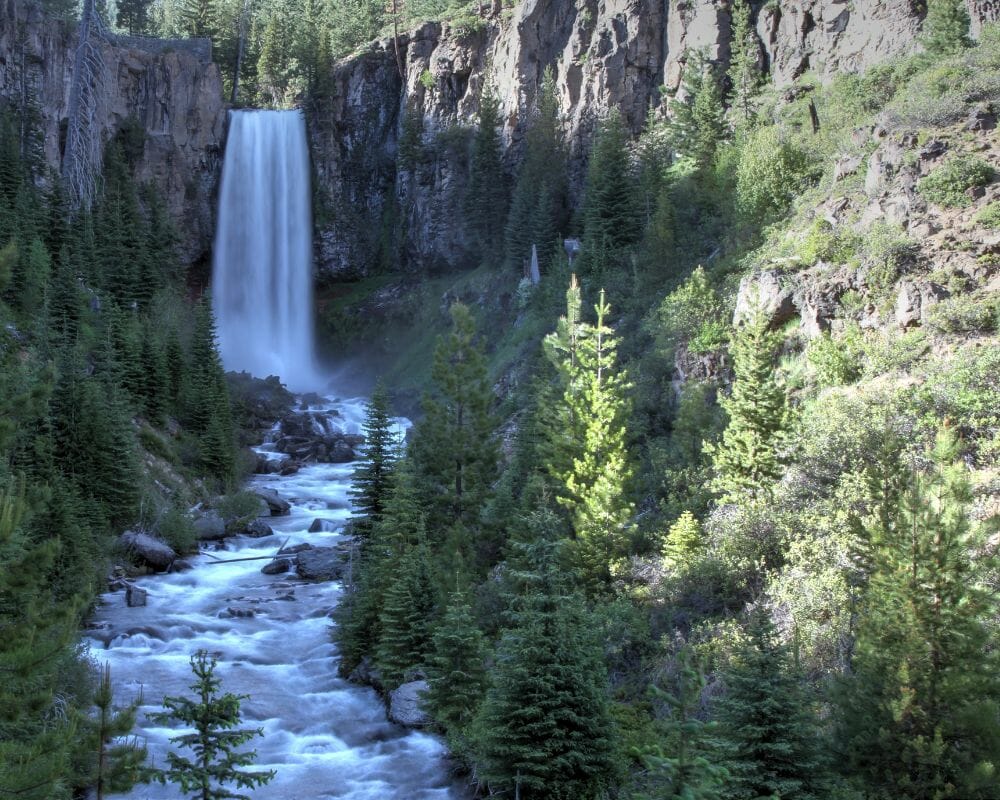
Tumalo fall is one of the most iconic waterfalls in Central Oregon. At nearly 100 feet in Deschutes National Park, Tumalo Falls boasts several stunning viewpoints, accessible hiking trails, other cascading waterfalls, and beautiful forests to wander through. The first glimpse of this picture-perfect waterfall will take your breath away.
During summertime, you can simply drive up to Tumalo Falls and then walk to a couple of overlooks. However, in the winter, they close the roads. So, you must park outside and walk 2.5 miles to the Falls.
Before heading out for the trip, let’s look at everything you need to know about the trails. Let’s get started!
Tumalo Creek Falls: In-and-out & Loop Trails
A few miles away from the trailhead in Deschutes National Forest, Tumalo Creek runs from Skyliner snow park to Tumalo Fall. While we’re all for in-and-out hikes, there’s something special about a loop hike. It just feels a little more adventurous. You will return to where you started a different way, never retracing a step, every view of a fresh one.
The Tumalo Falls Loop hike is a very rewarding average-length day height that you can do in the high desert of Central Oregon. You’ll travel a total of seven miles and climb about 1300 feet. You’ll have to start at about 5000 feet elevation at the trailhead. So, this can be a good height to escape the valley’s heat for a bit on a hot summer day.
How to get to Tumalo Falls Trail
To get to the trailhead for this hike, head West out of the Old Town part of Bend on Skyliners Road. After about 9 miles, shortly after the historic Skyliners neighborhood, the road beers right and turns into Tumalo Falls Rd. Then it’s a gravel road for a couple of miles until you dead end at the trailhead.
Equipment to Consider Bringing:
Let’s go over just a few things you might want to consider bringing for this hike, in addition to whatever you usually gear up with.
- trekking poles
- water shoes
- sun hat
- Northwest Forest Pass (for parking). We recommend getting this ahead of time. If you don’t have a chance, bring a $5 bill.
Tumalo Creek Falls hiking trails
So you made it to the trailhead; now what? Well, you can jump right into the hike, but right at the trailhead, you’ll find an excellent viewpoint for the main Tumalo falls as well as a trail you can take down to Tumalo Creek and follow up to the bottom of Tumalo falls if you want to do a little exploring first.
When you’re ready to get going, head off to the left of the interpretive signs up the North Fork Trail. You’ll soon approach a fork in the trail you can take to the right to get that view from the top of the falls. The trail branches off in various places in this area, but it all joins together again if you just keep going forward uphill.
This first section of the trail takes you to an upper viewpoint of Tumalo falls, then continues up along Tumalo Creek. The first short section to the upper viewpoint is the steepest part of this trail, but the trail itself is flat gravel. Once you continue past that upper viewpoint, it is a gentle, gradual accent for this section. But the trail becomes more typical_ rugged, rocky, and rudy kind.
When’s the best time of the year to hit this trail
Tumalo Creek Trail is a great to visit during the spring, summer, and fall.
All intersecting trails
As you follow this meandering path along Tumalo Creek, you’ll be greeted by a waterfall after a waterfall. The main Tumalo falls at the trailhead may be the biggest, but all of these smaller gems add up to something more. And they keep coming.
Swampy Lakes Trail
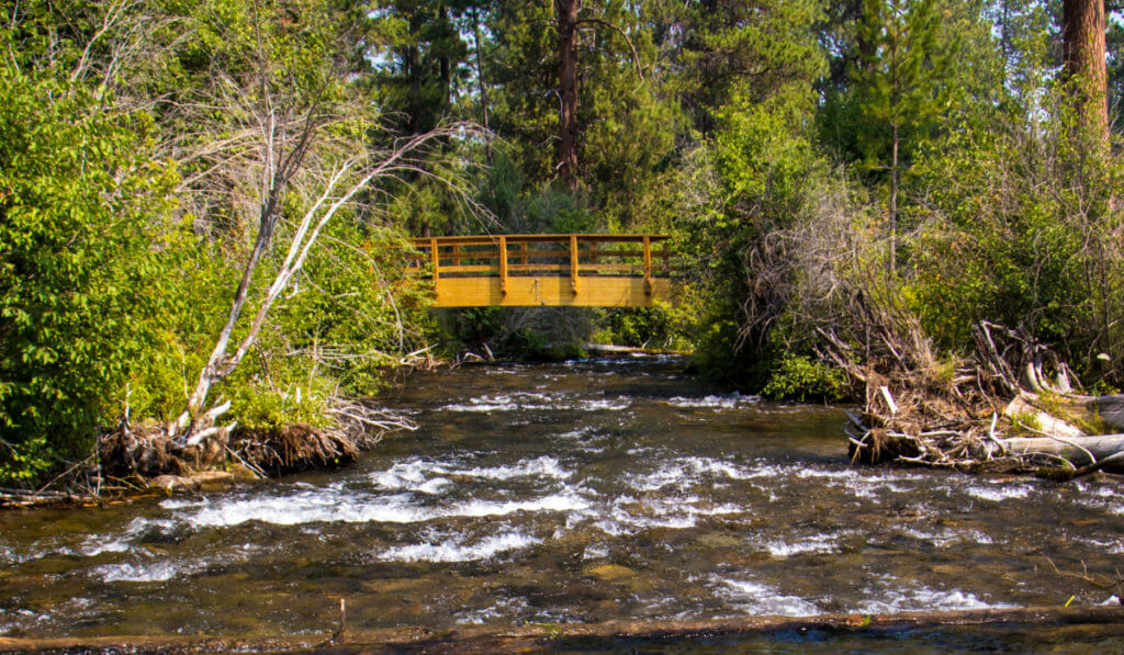
After a couple of miles, you’ll reach a log bridge going over a Creek. You’ll cross the bridge and meander slowly uphill for another mile, passing more waterfalls, which will now be on your left. After that mile, you’ll come to your first junction with the Swampy Lakes Trail, where we’ll be making a sharp left turn, ending section A of this loop.
The next section of this loop continues uphill for a bit but soon transitions to a steady downhill, which will continue the rest of the way. After less than half a mile, you will approach that Big Creek crossing we mentioned earlier. The main crossing is a huge log that you can try balancing across, but it may have water flowing around and over it.
Bridge Creek Trail
If you don’t feel like trying that, you can also go downstream where the water is not pooling behind logs and try wading through it, maybe with some added support from trekking poles. Soon after that crossing, you’ll find yourself gliding downhill on a more overgrown and exposed trail than before, with younger trees crowding the trail.
The trail will level out in less than a few miles, and you’ll approach the next section of the loop, starting at a junction with the Bridge Creek Trail. The last section of the loop is a relatively flat trail following along Bridge Creek to connect you back to the North Fork Trail just up from the trailhead.
Keep a lookout on your right for lovely views of Bridge Creek and maybe another small waterfall or two in the distance. You’ll come up on a small building on your right towards the end and veer off to the right, returning to where you started.
Frequently Asked Questions (FAQs)
Do you need a permit for Tumalo Falls?
There is a parking day use fee of $5 that you’ll have to pay. You can easily buy it online or purchase it at the spot on the trailhead. You’ll have to bring the exact cash, though. Alternatively, you can also use different passes such as an annual NW Forest pass or National parks/Interagency pass. Besides these, no other hiking permits are required.
How can I get to the bottom of Tumalo Falls?
Galveston turns towards Skyliners road after passing through century drive. Continue following the Skyliners for about ten and a half miles, then turn towards foreign service road 4601. You’ll see a trailhead of Tumalo Falls. Foreign service road 4601 is a gravel road about three miles to the bottom of the falls.
Is Tumalo Falls road paved?
Reach the Tumalo Fall by driving 8.8 miles up this road and then head right at an intersection. Here, the road becomes unpaved and passes through Tumalo Creek. On the other side of the road, turn left up Tumalo Falls road, also known as the National Forest road 4603, and head towards Tumalo Falls day use area by driving 2.4 miles up at the road’s end.
Can you hike the Tumalo Falls in the Winter?
The Tumalo Fall freezes in Winter for the most part. It’s trickling more than falling. Still, you can hike the trails if you want to. There, you’ll encounter beautiful snow views along the way. The way is paved, so you won’t even need your snow shoes for hiking.
Explore Our Central Oregon Collection
